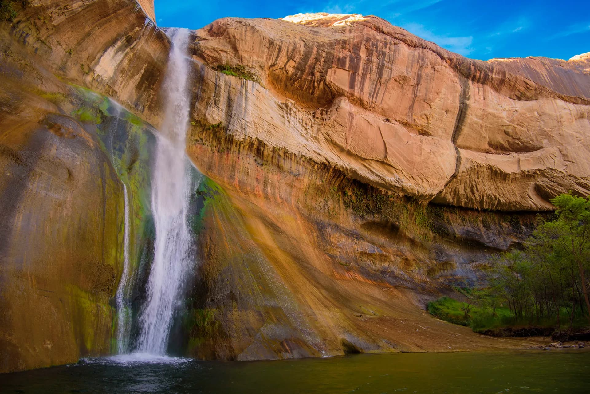
Escalante.town
Roads today
  • Highway 12wetCAUTION
  • US-89-- TRAFFIC ALERT: Crews are currently milling on the east side of US-89 from W 6850 S to 700 S. Crews are currently installing storm drain systems from W Center St to 300 N. Concrete flat work including the installation of curb and gutter is occurring between 900 E to 700 S. Repairing soft spots and potholes from 500 N to 750 N. TRAFFIC ALERT: Northbound US-89 at the SR-126 and US-89 intersection in South Willard will close to through traffic from Monday, May 19, through summer 2025. Drivers should follow the posted detour. -- UDOT will construct improvements along US-89 from the US-89/SR-126 intersection to just south of Hargis Hill Road in Willard. These improvements will replace subgrade material (e.g., compacted gravel) and pavement which has reached its operational expectancy and become unstable. Additionally, much of the existing drainage along this section of US-89 will be upgraded to avoid pooling and roadway storm runoff (i.e., sheet flow) during stormy weather. This will extend the lifetime of the road, while creating a safer, more comfortable road for drivers.CAUTION
Right now
41°/ 49°
Clear

Places

Escalante places and day trips

A source-backed index for Escalante, Grand Staircase, Scenic Highway 12, Bryce-side day trips, Boulder, and the west edge of Capitol Reef. This is a static index, not a live map or current-conditions feed.

Source confidence

34 launch records are marked official-source and carry last-verified dates.

Map status

Launch uses a dense static index. Use official links on each card for changing road, weather, rule, and condition context.

Highway or town access

10 records

Records whose stored access context mentions paved highway, state route, or town access.

Remote or primitive road context

7 records

Records whose stored access context mentions remote, primitive, dirt, backway, or trailhead access.

Destination-specific facilities

34 records

Records with parking, restroom, water, or fee fields that should be checked against official sources.

Related planning links

Use places with the rest of the trip plan

Move from source-backed place records into hikes, activity planning, official sources, and visitor services.

Collection

Hikes

Source-backed hiking destinations with road, seasonality, and official-source context.

Top
hike
Official sourcehike

Queen's Garden / Navajo Loop

NPS Bryce hike combining the Queen's Garden and Navajo Loop areas, included as a Bryce day-trip option from Escalante.

Land manager
National Park Service
Access
Access: Bryce Canyon National Park roads
From Escalante
1 hr 30 min
Last verified
Last verified: May 9, 2026
hike
Official sourcehike

Hickman Bridge

Popular NPS Capitol Reef hike included as a long day-trip option from an Escalante basecamp.

Land manager
National Park Service
Access
Access: Capitol Reef National Park roads
From Escalante
1 hr 45 min
Last verified
Last verified: May 9, 2026
hike
Official sourcehike

Capitol Gorge

NPS Capitol Reef gorge hike context for visitors making Capitol Reef the eastern edge of an Escalante day trip.

Land manager
National Park Service
Access
Access: Capitol Reef National Park roads
From Escalante
1 hr 55 min
Last verified
Last verified: May 9, 2026

Collection

Scenic drives

Highway and backway corridors with official road and land-manager links.

Top
scenic drive
Official sourcescenic drive

Capitol Reef Scenic Drive

NPS Capitol Reef scenic-drive route, included as a long east-side day-trip option from Escalante.

Land manager
National Park Service
Access
Access: Capitol Reef National Park roads
From Escalante
1 hr 45 min
Last verified
Last verified: May 9, 2026

Collection

Parks and public lands

National monument, state park, and public-land records with manager and review metadata.

Top

Collection

Viewpoints

Overlooks and low-commitment scenic stops with coordinates and official sources.

Top
viewpoint
Official sourceviewpoint

Bryce Amphitheater Viewpoints

NPS-described viewpoint area around the Bryce Amphitheater, useful for a first Bryce day trip from Escalante.

Land manager
National Park Service
Access
Access: Bryce Canyon National Park roads
From Escalante
1 hr 30 min
Last verified
Last verified: May 9, 2026

Collection

Towns and service bases

Nearby towns and visitor-service bases that shape Bryce, Boulder, and Capitol Reef day-trip planning.

Top

Collection

National parks

Bryce Canyon and Capitol Reef records framed as day trips from Escalante.

Top

Collection

Forest areas

High-elevation forest corridors, red-rock gateway areas, and official-source condition context.

Top

Collection

Historic and cultural sites

Cultural, historic, and interpretive stops that fit an Escalante day-trip plan.

Top
historic site
Official sourcehistoric site

Fruita, Capitol Reef

NPS-described Fruita orchard and historic-area context inside Capitol Reef, relevant for a longer day trip from Escalante.

Land manager
National Park Service
Access
Access: Capitol Reef National Park roads
From Escalante
1 hr 40 min
Last verified
Last verified: May 9, 2026
historic site
Official sourcehistoric site

Capitol Reef Petroglyph Panel

NPS Capitol Reef cultural site near the park's main visitor corridor, included as an east-side day-trip stop from Escalante.

Land manager
National Park Service
Access
Access: Capitol Reef National Park roads
From Escalante
1 hr 45 min
Last verified
Last verified: May 9, 2026

Collection

Trailheads

Access records for destinations where road, parking, and condition links matter.

Top

Collection

Visitor services

Public visitor-service records for official in-person planning support.

Top